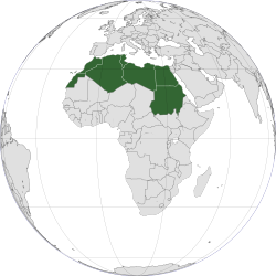
North Africa
Population density of Africa (2000)
North Africa includes a number of Spanish and Portuguese possessions, Plazas de soberanía, Ceuta and Melilla and the Canary Islands and Madeira.[3] The countries of North Africa share a common ethnic, cultural and linguistic identity that is unique to this region. Northwest Africa has been inhabited by Berbers since the beginning of recorded history, while the eastern part of North Africa has been home to the Egyptians[4]. Between the A.D. 600s and 1000s, Arabs from the Middle East swept across the region in a wave of Muslim conquest. These peoples, physically quite similar, formed a single population in many areas, as Berbers and Egyptians merged into Arabic and Muslim culture. This process of Arabization and Islamization has defined the cultural landscape of North Africa ever since.
The distinction between North Africa, the Sahel and the rest of the continent is as follows:
Nineteenth century European explorers, attracted by the accounts of Ancient geographers or Arab geographers of the classical period, followed the routes by the nomadic people of the vast "empty" space. They documented the names of the stopping places they discovered or rediscovered, described landscapes, took a few climate measurements and gathered rock samples. Gradually, a map began to fill in the white blotch.The Sahel or "African Transition Zone" has been affected by many formative epochs in North African history ranging from Ottoman occupation to the Arab-Berber control of the Andalus.[6][7] As a result, many modern African nation-states that are included in the Sahel evidence cultural similarities and historical overlap with their North African neighbours.[8] In the present day, North Africa is associated with West Asia in the realm of geopolitics to form a Middle East-North Africa region.[9] The Islamic influence in the area is also significant and North Africa is a major part of the Muslim world.
The Sahara and the Sahel entered the geographic corpus by way of naturalist explorers because aridity is the feature that circumscribes the boundaries of the ecumene. The map details included topographical relief and location of watering holes crucial to long crossings. The Arabic word "Sahel" (shore) and "Sahara" (desert) made its entry into the vocabulary of geography.
Latitudinally, the "slopes" of the arid desert, devoid of continuous human habitation, descend in step-like fashion toward the northern and southern edges of the Mediterranean that opens to Europe and the Sahel that opens to "Trab al Sudan." Longitudinally, a uniform grid divides the central desert then shrinks back toward the Atlantic Ocean and the Red Sea. Gradually, the Sahara-Sahel is further divided into a total of twenty sub-areas: central, northern, southern, western, eastern, etc.
In this way, "standard" geography has determined aridity to be the boundary of the ecumene. It identifies settlements based on visible activity without regard for social or political organizations of space in vast, purportedly “empty” areas. It gives only cursory acknowledgement to what makes Saharan geography, and for that matter, world geography unique: mobility and the routes by which it flows.
— An atlas of the Sahara-Sahel : geography, economics and security[5]
Some researchers have postulated that North Africa rather than East Africa served as the exit point for the modern humans who first trekked out of the continent in the Out of Africa migration.[10][11][12]
Contents
Geography
North Africa has three main geographic features: the Sahara desert in the south, the Atlas Mountains in the west, and the Nile River and delta in the east. The Atlas Mountains extend across much of northern Algeria, Morocco, and Tunisia. These mountains are part of the fold mountain system that also runs through much of Southern Europe. They recede to the south and east, becoming a steppe landscape before meeting the Sahara desert, which covers more than 75 percent of the region. The tallest peaks are in the High Atlas range in south-central Morocco, which has many snow-capped peaks.South of the Atlas Mountains is the dry and barren expanse of the Sahara desert, which is the largest sand desert in the world.[13] In places the desert is cut by irregular watercourses called wadis—streams that flow only after rainfalls but are usually dry. The Sahara’s major landforms include ergs, large seas of sand that sometimes form into huge dunes; the hammada, a level rocky plateau without soil or sand; and the reg, a level plain of gravel or small stones. The Sahara covers the southern part of Algeria, Morocco and Tunisia, and most of Libya. Only two regions of Libya are outside the desert: Tripolitania in the northwest and Cyrenaica in the northeast. Most of Egypt is also desert, with the exception of the Nile River and the irrigated land along its banks. The Nile Valley forms a narrow fertile thread that runs along the length of the country.
Sheltered valleys in the Atlas Mountains, the Nile Valley and Delta, and the Mediterranean coast are the main sources of fertile farming land. A wide variety of valuable crops including cereals, rice and cotton, and woods such as cedar and cork, are grown. Typical Mediterranean crops, such as olives, figs, dates and citrus fruits, also thrive in these areas. The Nile Valley is particularly fertile, and most of the population in Egypt live close to the river. Elsewhere, irrigation is essential to improve crop yields on the desert margins.


No comments:
Post a Comment